Upcoming Events and Programs
K-12 Students
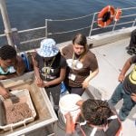
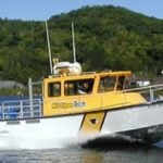
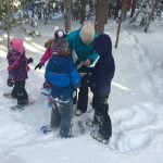
- Outdoor Science Investigation Field Trips for Winter, Spring, and Fall 2023
- Family STEM Nights: reserve a date by contacting the Center by using by email (cseo@mtu.edu) or by telephone (906-487-2412).
- Geospatial Escape Trailer School Registration (available for school visits April 17 – May 26, 2023)
Teachers
- Family Engineering – Training opportunities available
- Workshops and Professional Learning
- Also check for upcoming workshops for educators and community partners on the Lake Superior Stewardship Initiative calendar of events.
- Resource Clearinghouse in partnership with Western UP STEM Network.
Community Events
- 2023 Copper Country Strawberry Festival “Ride the Waves” Scientific Excursions Saturday, July, 8 2023 [12:30-6:00], Chassell Marina, Chassell, MI
- 2023 Sustainability Film Series and Facilitated Discussion Jan-May (3rd Thursdays)
- Archive Green Films 2011-2018 are available for a 2-week checkout for Classroom, Meetings or Home Viewing. To borrow films, contact: cseo@mtu.edu.
Conferences
March 3-4, 2023 ~ Annual Michigan Science Teachers Association Conference at Lansing Center and Radisson Hotel in Downtown Lansing.April 20-23, 2023 ~ Lake Superior Youth Symposium at the Sigurd Olson Environmental Institute, Northland College in Ashland Wisconsin- July 18-20, 2023 ~ Annual Michigan Council of Teachers of Mathematics Conference at Detroit Public Schools in Detroit, Michigan.
- September 29 – October 1, 2023 ~ Michigan Alliance for Environmental & Outdoor Education annual conference in Alpena. — Details will be published soon.
MTU Students
- Intern Application (for teaching K-5 after school classes or leading K-8 outdoor science field trips)
Store
- Family Engineering Activity & Event Planning Guide
- Lake Superior Floor Maps (provide one month for delivery)